Which Methods did We Deploy?
Since 2010, BOGA has used various methods of survey archaeology in tandem. Due to the density of architectural remains and the propensity of settlements, the field research prioritized mapping and architectural documentation. In the building survey and cartographic mapping, in addition to traditional methods of documentation, we have also deployed both terrestrial and airborne laser scanning (LiDAR) and photogrammetry (Structure-from-Motion). As the most common finds encountered during the intensive and extensive surveys, we have focused on the study of pottery and architectural sculpture. Across the survey region, we have collected samples for geological and archaeometric analysis (e.g., Nuclide Cosmogenic Exposure for dating stone quarries, Optically Stimulated Luminescenc (OSL) for dating architectural terraces). To better understand the changes in the cultural landscape across ages, we used the method known as Historic Landscape Characterization (HLC). As part of our work on intangible cultural heritage, we have conducted oral history interviews with the local inhabitants.
Extensive and Intensive Pedestrian Survey
The extensive survey involves the study and low-resolution documentation of the study area and surface remains in a large area. This may include a reconnaissance survey in which study areas are selected based on existing knowledge, such as local guides, topographical features, descriptions in primary sources or travellers’ accounts. It may also involve ground truthing the data acquired via air photography and satellite imagery. Survey areas may also be determined systematically or randomly to allow for statistical analysis. Extensive survey allows the archaeologist to understand modern land use, field systems, vegetation cover, soil properties, topography and geomorphology, surface visibility, all of which, help guide the coverage and the sampling strategy in an intensive survey.
In an intensive pedestrian survey, surveyors spaced out at regular intervals walk in grids or along transects. Field walkers collect and/or record surface artifacts (e.g. sherds, lithics, metal) in such a way to plot them in the corresponding survey units. Like in the extensive survey, field walkers also make notes about surface visibility, topography, geomorphology, field systems, land use, etc. As such, intensive surveys cover smaller areas at a high resolution. More significantly, the use of a predetermined sampling strategy creates a dataset that is statistically more reliable. To reduce the biases and inconsistencies in data collection, survey teams may revisit the same area under different conditions (e.g., another season).

Dana Adası intensive survey (Noah Kaye and Nicholas K. Rauh, 2017)
Mapping and Building Survey
Mapping involves drawing the plans of archaeological features and topography using measuring devices such as Total Station and GNSS. For example, this was the main field method to understand the distribution and the size of quarry areas and their spatial relationship with the settlement. This has also served as the basis for the so-called Quarry Inventory, which included the detailed documentation of all the features pertaining to quarrying, such as stone extraction channels, tool marks, transport ramps.
Building survey is the two dimensional representation of a three dimensional building in the form of plans, sections, elevations, and detail drawings. It involves the detailed documentation and analysis of the structural and spatial properties of buildings, and their architectural elements (e.g., doors, windows, arches). It is the most common type of work in the field for the preparation of the Architectural Inventory.

Section drawing (Mine Esmer, 2016)

Mine Esmer, mapping on Dana Island (2019)

Settlement plan of Boğsak Island from 2015 (Deniz Coşkun and Mine Esmer, 2015)

Lara Taş setting up the Total Station (2012)

Total Station, often used in archaeological fieldwork, is an instrument used in measuring the terrestrial coordinates of sites, buildings, and remains in order to prepare scaled plans, sections, elevations, topographic maps, etc.
Pottery Studies
The pottery study starts with the collection of surface pottery following a sampling strategy based on factors such as research questions, the terrain, and the resources of the project. The distribution of sherds is always recorded on a map. The characteristics of the sherds (e.g., fabric, color, decoration, weight, count) are recorded to date the pieces, determine their functions, understand their provenance, etc. The sherds may be documented in the field or selectively brought into the office where they are washed, drawn, photographed, and further studied. The Chronotype classification system used by BOGA in the field and office allows the pottery specialist to create a modifiable hierarchy of pottery chronotypes using the characteristics that can be identified. Each chronotype is designated by a combination of features such as chronology, fabric, and decoration. In this system, the field walker collects all the unique artifacts. Even if an artifact cannot be placed in a pre-existing type, it is placed in a newly created chronotype, which may later be further populated with discoveries in the field.

Dana Island lower settlement ceramics (Nicholas K. Rauh, 2017)
Three-Dimensional (3D) Modelling
Photogrammetry
Structure-from-Motion (Sfm) is a photogrammetry method that allows the production of 3D models using still photographs taken from multiple angles and locations. In other words, using specialized software, a consecutive series of 2D photographs are transformed into scaled 3D models of objects ranging from artifacts to architectural elements and buildings.
Ozan Sepetçi taking photographs for SfM (2019)
The 3D model of a door post with a cross relief on Dana Island, created via SfM (2019)
Three-Dimensional (3D) Modelling
Laser Scanning - LiDAR (Light Detection and Ranging)
LiDAR, is a remote sensing method, that collects three-dimensional information about objects and terrains using pulsed laser (e.g., visible, ultraviolet, near infrared, green light) emitted from a scanner. Light in the form of a pulsed laser measures the distances to the object by measuring the return time for the reflected light. Terrestrial LiDAR is mounted on a tripod on land (stationary or mobile) while airborne LiDAR is mounted on drones, helicopters, and airplanes.
The laser beams emitted by the laser scanner hit surfaces on the ground and return to the source. As such, the scanner collects coordinate data (x, y, z) about the remains and the terrain. By processing the encoded data, it is possible to create 3D models of the scanned objects.
Terrestrial Laser Scanning (TLS) (Terrestrial LiDAR / Topographic LiDAR)
In the past decade, the rapid development of new technologies enabled the usage of recent and newly emerging digital tools in the study of archaeological, historic, and urban landscapes. Among them, Terrestrial Laser Scanners (TLS) or LiDAR have become increasingly affordable and accessible, while producing accurate and precise geospatial data with significantly reduced time in the field.
In collaboration with Newcastle University, we have used TLS for the documentation of the church complex (Churches I and V) on Boğsak Island and the so-called Ashlar Complex on Dana Island. In this, Dr. Alex Turner has operated the Faro Focus S 350 scanner and Faro reference spheres (diameter 140 mm) used as targets. This model that can capture data as far as 350m, is vey suitable for scanning archaeological remains in the open air. Its in-built HDR camera with 8 megapixel resolution collects realistic color data even in extreme (very bright or dim) lighting conditions. The laser scanner mounted on a tripod is placed on multiple stations placed in such a way to scan all the surfaces of the object. To ensure the superimposition of the scans from different stations, each consecutive scan should have at least three target spheres (diameter: 140 mm) in the same position. After the scan is successfully completed, a specialized software allows the processing of the data to create a three-dimensional point cloud. The point cloud may be used to create scaled orthophotos for drawing two-dimensional plans, sections, and elevations, or to generate 3D models of the scanned object. TLS gives the researcher the opportunity to study and digitally experience the scanned object beyond the fieldwork.

Terrestrial LiDAR at the so-called Ashlar Complex on Dana Island (2017)

Cem Ardıl placing the Terrestrial Laser Scanner in a suitable location on the stepped avenue on Boğsak Island (2016)

Architectural drawing of the eastern façade of Church V on Boğsak Island, drawn using the scaled orthophotos produced by the Terrestrial LiDAR (drawing by Nihan Arslan, 2019)*

Proposal for the reinforcement of the eastern façade of Church V on Boğsak Island (Nihan Arslan, 2019)*

Hypothethical reconstruction of the east façades of Church I and V on Boğsak Island (Nihan Arslan, 2019)*
*Arslan, N. (2019). Taşucu Körfezi Boğsak adası'nda geç antik döneme ait iki kilisenin korunması için öneriler. (Yayımlanmamış yüksek lisans tezi). Fatih Sultan Mehmet Vakıf Üniversitesi Lisansüstü Eğitim Enstitüsü Mimarlık Anabilim Dalı, İstanbul.
Airborne LiDAR
Airborne LiDAR includes a laser scanner, a high-resolution camera, a high-accuracy GPS, and an Inertial Measurement Unit (IME) mounted on an airplane, helicopter, or a drone. The laser beams emitted to the ground return to the scanner, which records three-dimensional geospatial data about the terrain and the archaeological remains. This system collects data about position, orientation, scan angles, and calibration, in such a way to produce a “point-cloud” which includes 3D spatial coordinates of all the surface points from which the laser is reflected. The data which is later processed in specialized software enables the creation of a 3D point cloud the scanned area. This data may be used to create 2D and 3D representations such as Digital Elevation Models, building models, orthophotos,etc. Especially for large areas, among the most significant advantages of airborne LiDAR is its capability to capture data about the surfaces under vegetation. The beams going through the gaps between leaves and branches are especially invaluable for the thick vegetation cover in the Meditterranean.
A collaboration between the Boğsak Archaeological Survey and Purdue University’s ROSETTA Initiative (Remote Sensing Technologies and Techniques in Archaeology), resulted the first use of airborne LiDAR in the archaeology of Mediterranean Turkey. Dana Island was the first archaeological case study of the ROSETTA Initiative. The large size of the island, the vegetation cover, the difficulty of the terrain, and the juxtaposition of quarries and the settlement, make Dana Island a very important site for the application of airborne LiDAR. The study of the LiDAR data will allow the researchers to reconstruct the archaeological remains under the tree and maquis cover and to have a holistic understanding of the site.

The airborne LiDAR records not only the remains on the terrain but also helps locate underground features with openings, such as cisterns (Ayman Habib and Evan Flatt, 2019)

Airborne LiDAR mounted on a drone, and the GPS unit set on a tripod (2019)

To be able to discern the remains under vegetation, the data should be processed using complex algorithms (Yi Chun Lin and Hilal Küntüz, 2020)
RTI (Reflectance Transformation Imaging)
RTI is a computational photographic technique that reveal the details on eroded surfaces. By placing the object and the camera in stationary positions, a series of photographs are taken in a certain order following the shape of a dome facing the object. In each photograph, the object is illuminated from a different angle but at a fixed distance. All the photographs are subsequently combined in a specialized software to create an interactive relightable file. By digitally changing the lighting conditions, the user may study the characteristics of the surface which are otherwise invisible or illegible. BOGA used RTI to study the Asteria inscription (5th-6th c. CE) found on Boğsak Island in the 1960’s. It was also applied to toolmarks on Dana Island and an eroded surface in Church V on Boğsak Island.

The Asteria inscription in the Silifke Museum: inscription from Boğsak Island that mentions the name of the settlement as Asteria (2018)
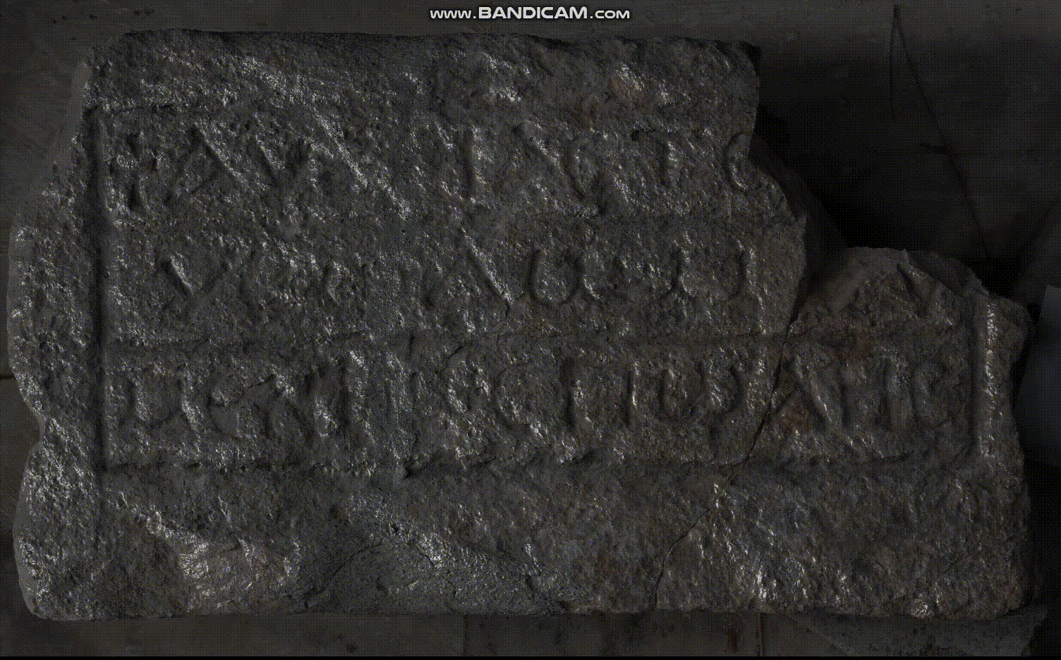
The interactive file of the Asteria (Boğsak) inscription created using RTI (Hilal Küntüz, 2018)
Geological and Archaeometric Sampling
Archaeometric sampling and analysis allows the study of the physical and chemical properties of the materials (e.g., stone, mortar, brick) used in buildings, and determine their provenance. The geological analysis method of Optically Stimulated Luminescence (OSL) profiling allowed our team to date the construction and lifespan of agricultural terraces on land. On Dana Island, we have sampled a number of quarries to be able to date the period of their first usage. In this, the dating was based on the geological method known as Nuclide Cosmogenic Exposure.
Historic Landscape Characterization
In 2015, the Newton Advanced Fellowship of the British Academy enabled a collaboration between Mimar Sinan Fine Arts University and Newcastle University. The joint project focused on the implementation of the landscape analysis method of Historic Landscape Characterization (HLC) for the diachronic analysis of the cultural landscapes in the study region. HLC, commonly used in Western Europe, was integrated into BOGA’s landscape investigations in the field. The main component of HLC is carried out in a computer environment, using Geospatial Information Systems (GIS) and a database software. The remote analysis used cartographic maps (1: 25,000), orthophotos, and Black and White aerial photographs taken in 1953-1990, created by the General Command of Cartography in Turkey. The comparative analysis of this data helps th researcher determine a set of landscape character types (e.g. types of terraces, fields, settlements), which are represented in GIS in the form of joining polygons for the pre-selected periods based on the dates of thee orthophotos and/or air photographs. Significant properties of each polygon (e.g., usage, vegetation) is recorded in the database linked to the GIS platform. This work, done remotely in the computer environment, is based on the extensive survey in the study region before the beginning of the HLC project and is further ground-truthed in the field as needed. Thus, the data and analysis based on remote sensing is regularly checked against archaeological field data in such a way to increase the accuracy of the drawings and the reliability of the interpretation. HLC, is a method that helps the archaeologists, heritage professionals, as well as government bodies to better understand the continuities and transformations in cultural landscapes and make informed policy decisions for the future.
Oral History
Oral history records the intangible cultural heritage and people's perception of landscape and cultural heritage (e.g. place names, perception of cultural environment, use of natural resources) through interviews with local people based on a set of questions prepared in advance.
Interview with Cennet Yörüsün:
Date: Tuesday, 04.08.2014
Time: 11.15-12.45
Place: The house of Cennet Yörüsün at the entrance of Boğsak Village
Interviewer: Adil Yılmaz
Cennet Yörüsün (the wife of Kerim Ali Yörüsün's paternal uncle): She was born in 1939. Until her marriage in 1963, she had a transhumant life. With her husband, she settled in Boğsak in 1964. Her husband passed away seven years ago. Now she lives with her children. She is unable to walk due to a disability. Her grandfather is a veteran of the war in Yemen and her father of the Turkish War of Independence. She has four children (two sons, two daughters) and seven grandchildren. Neither of his sons studied. One of her daughters graduated from high school, and the other graduated from university. Her daughter, who graduated from the university, is currently working as the chief clerk at the Silifke Courthouse. Cennet Yörüsün did not go to school as her family was transhumant. Back then, only boys were sent to school in the Işıklar Village so that they could learn just how to read letters. That's why she could not attend any school. Nevertheless, she learned to read and write during the Literacy Campaign after 1980.
“The people of the nearby Akdere Village call the people of our village Bolacalı / Bolaçlı. We call them Işıklı¹. The nearby Bağlan and Çatak Villages are also from Bolaca, just like us. My father used to say that we came from the environs of Kars. But I don't know because I didn't ask exactly.
When the people of the village settled in Karabucak where the old village was situated, there were seven black tents. When the weather was good, they stayed in tents, other times they stayed in the nearby caves. A man named Mustafa Hoca, who came from outside as a groom, taught the villagers how to weave cloth. The peasants began to earn their living in this way.
I don't know whether Karabucak had any ruins when the villagers settled there. As there are rocks everywhere, they shaped them and used them as walls.
In my childhood and youth, we used to leave here and migrate to the highlands in Karaman. At night-times, all the goods were loaded on camels, and the children would walk barefoot. It would take 10-15 days to get from here to Karaman. We used to stay in a different place every night. When we get there, the men would plow the fields and threshed the grais. Then we would go back in the same way towards winter.
My late husband was a farmer until 1964. The place where the Intermot hotel is located today belonged to them. He used to cultivate sweet and unripe melons. Later, we sold that place to motel owners, and opened a restaurant in the stone building across the canal for two years. Before that, my father was working as a stonemason in the village. One day, my husband bought a boat from Taşucu and we started to earn our living by fishing. He was the first to bring fishing to the village. I helped him until he got sick. At that time, they did not know much about fishing. For this reason, they would take the torn nets to Taşucu for repair, and bring them after they had been mended there. My husband learned how to sew there and began to mend the nets on his own. We used to make ropes from goat hair and try to fix the nets with it. Unlike today, different types of threads did not exist back then.
As they were novices in fishing, they first thought that the groupers were inedible and threw them back into the sea. One day, they were surprised to see that a foreign boat was full of groupers. After the boat owner told them, "Fish the groupers every day. I will buy it from you. This is the best fish", they started fishing them. Until then, they thought groupers were poisonous.
After my sister passed away, my brother-in-law went to Tokmar village to ask the hand of a girl. He said to my husband, "Let's bring them groupers” My husband answered, "they are poisonous. You may take those people's life". But they still brought them as gifts. In the house where they went to make their debut in the evening, the host family ate the fish, but my brother-in-law did not eat it because he thought they were poisonous. Nothing happened to the host family. Before returning to home, they said, "Bring that fish again."
There was no school in the village until 1968. The children would cross the hill and go to other villages. A teacher was appointed to the village that year. Since there was no school building that year, teaching was held in the village mosque.³ The following year, education started in the school building.
Electricity came to the village in 1978.
The creek bed in the village would only fill up when there was a flood, and the school building would also be flooded. When it rained, everyone would go to save their child. At that time, the village's only source of water was the well, which still stands on the land opposite the mosque. We used to salt the goatskin and make tuluk⁴. We used to carry water to the houses with it. The water of the well dwindled but never ceased. We used to do laundry there too. Women from Boğsak and Karabucak would come, and we would wash our clothes together.
They called the place where the well was located the infidel grave. There were old stones there. Later, they disappeared. In the place where the camping is located today, there was a place we call the "Infidel Castle". There were many high walls. They crushed up the walls there later. There is nothing left.
Of the seven tents that first established the village, 17 were martyred during the war. My father was young at that time. When they said "Arab soldiers are coming" during the invasion, everyone was afraid and ran away.⁵ My grandfather stayed in Yemen.⁶ My husband's uncle was also taken prisoner there. Then he ran away. On the way, they used to break the bellies of the Turkish soldiers saying, "they have gold in their bellies". My uncle came to a river, where the Arabs asked, "Do you have any money?" He took out two medjidies in his pocket and passed the river like that. After coming here by walking from the mountains, he knocked on the door of a nomad and asked for bread. The nomad woman did not give food even though she had gold on her, because she knew he was a fugitive. "I came from Yemen. I went hungry in my own hometown," he said.
When I was young, foreign ships used to come to the Boğsak Bay. A lot of people would come out of it and travel the mountains and forests. While they were there, none of the women and girls could go out as they were afraid of them. Now they can't come as they want.
For a long time, I herded goats. My husband said let's leave the goats on the island.⁸ We left four goats on the island. A few days later, he said that they died. Couldn't believe it, I went to have a look. They were really dead. One of them gave birth to its baby in there by the grave⁹, and it died too. I was very sad and cried.
I don't know the island very well due to my illness. All I know is there are some structures that are visible. There is a tomb, and then there are some walls.
Once a donkey was left on the island. A woman living alone in the village could not take care of her donkey in winter, so they took it to the island and left it here. When I herded my livestock on the shore, it would come up to the shore of the island and shout.
We bought rabbits for our grandchildren. When it started attacking my chickens, we left it on the island. They bred there. Later we heard that they were all hunted. They are gone now.
A butcher from Belen brings his cattle to Dana Island in winter times. He's still bringing them to the island. He used to take the animals that stayed there all winter and take them to the plateau in the spring. He had hundreds and thousands of animals. He was taking boats from the Mavikent side. Sometimes he couldn't find some of the animals. Now a few of them are roaming the island.
People in old times were better. Money was little, but they worked hard and lived long. They are now dying of disease at a young age. Now, when the Nuclear Power Station is built here, everyone will get sick. There will be no fish in the sea. They said that the soil will also be poisoned.
It is better that the highway was taken out of the village. In the past, our chickens, cats, and dogs were crushed when the road passed through the village. Now this problem went away.
Sometimes, when we look at the village from the house, I say that our people settled in the worst place as there is no soil or water here. Looking at the beauty of the sea and the environment, sometimes I say that our people settled in the most beautiful place.
Today's young people do not know the troubles we went through. They have everything within their arm's reach. It's a lot of work for those who work here. There's a lot of money to be made. When I see unemployment in metropolitan cities on television, I feel grateful.
In the past, they wouldn't even let us hammer a tent nail. Now it's all concrete buildings. Now that there is no one left, I miss the old days.”
¹ Işıklılar Is a great tribe known in the seventeenth-eighteenth centuries. A branch of the tribe lives in the mountainous villages of the Soma district in the Manisa province. One of the villages is called Işıklar. (A.Y.)
² Village refers to Karabucak (A.Y.) which is where the locals lived before Boğsak
³ The old village mosque. It was located on the site of the present mosque.
⁴ Leather bottle (A.Y.)
⁵ In this context, Arab means soldiers of African descent in the British and French Occupation armies (A.Y.)
⁶ Martyrdom (A.Y.)
⁷ Husband's uncle (A.Y.)
⁸ Boğsak Island (A.Y.)
⁹ Church V is known is the grave (A.Y.)
*Adil Yılmaz and Cennet Yörüsün (2014)
